
Another small earthquake has been recorded in northern Arkansas, adding to several recent tremors in the region.
According to data from the U.S. Geological Survey, a magnitude 2.1 earthquake occurred Monday, November 9, 2026, at approximately 3:38 AM Central Standard Time.
The epicenter was located approximately 8 miles east of South Lead Hill, near the Diamond City area of northern Arkansas.
USGS data placed the earthquake approximately 2.6 kilometers, or 1.6 miles, beneath the Earth’s surface.
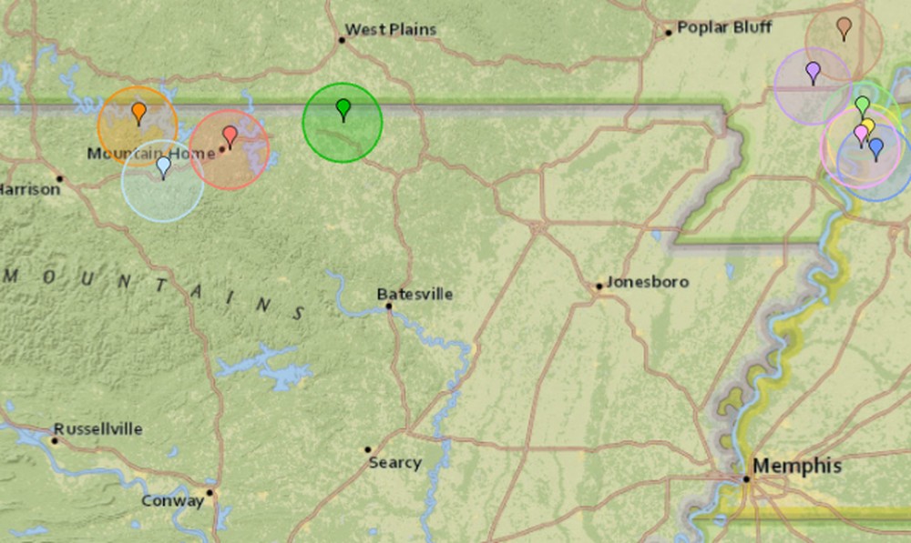
The earthquake is the latest in a series of small seismic events recorded across northern Arkansas, southeastern Missouri, and northwestern Tennessee in recent weeks.
November 9, 2026: Diamond City Area
- Magnitude: 2.1
- Time: 3:38 AM CST
- Location: Approximately 8 miles east of South Lead Hill, Arkansas
- Depth: Approximately 2.6 kilometers
USGS records show the event was reviewed by seismic specialists.
November 1, 2026: Salem Area
- Magnitude: 2.2
- Time: 9:10 PM CST
- Location: Approximately 4 miles north-northwest of Salem, Arkansas
- Depth: Approximately 3.9 kilometers
The earthquake appeared in regional earthquake listings associated with Horseshoe Bend, although the USGS epicenter was north-northwest of Salem.
October 29, 2026: Yellville
- Magnitude: 2.4
- Time: 12:44 AM CDT
- Location: Approximately 2 miles east of Yellville in Marion County
- Depth: Approximately 7.7 kilometers
This was the strongest of the 4 northern Arkansas earthquakes highlighted in this report.
October 25, 2026: Mountain Home
- Magnitude: 2.1
- Time: 7:46 PM CDT
- Location: Approximately 1 mile east of Mountain Home in Baxter County
- Depth: Approximately 10.6 kilometers
The Mountain Home earthquake was also reported by the U.S. Geological Survey.
Additional earthquake activity has been recorded in southeastern Missouri and northwestern Tennessee.
The following dates are based on Coordinated Universal Time, or UTC:
- November 5, 2026: Tiptonville, Tennessee. Magnitude 1.6, depth 8 kilometers
- November 3, 2026: Tiptonville, Tennessee. Magnitude 1.6, depth 9 kilometers
- November 1, 2026: Ridgely, Tennessee. Magnitude 1.7, depth 5 kilometers
- October 31, 2026: Parma, Missouri area. Magnitude 1.8, depth 15 kilometers
- October 29, 2026: Tiptonville, Tennessee. Magnitude 2.3, depth 10 kilometers
- October 28, 2026: Matthews, Missouri area. Magnitude 1.7, depth 5 kilometers
The Arkansas Geological Survey explains that earthquakes smaller than magnitude 2.5 are generally too weak to be felt by most people, although some residents near an epicenter may notice minor shaking.
Earthquakes occur when energy is released along fractures or faults in the Earth’s crust.
Arkansas has a history of seismic activity, including earthquakes associated with the New Madrid Seismic Zone in the northeastern part of the state and surrounding areas.
The New Madrid Seismic Zone extends through portions of Arkansas, Missouri, Tennessee, Kentucky, and Illinois.
Scientists continue to monitor earthquakes throughout the region using seismic instruments.
The recent small earthquakes do not, by themselves, establish that a larger earthquake is imminent.
Residents who experience shaking can report their observations through the USGS Did You Feel It? reporting system.
Earthquake measurements and locations may be revised as additional seismic data are reviewed.
- U.S. Geological Survey
- November 9 Diamond City Area Earthquake
- Arkansas Geological Survey
- Report Earthquake Shaking
HAVE INFORMATION YOU WOULD LIKE TO SHARE? Share your community news, announcements, sports results, and upcoming events with the ArkansasRadio.com family of radio stations. Submit your event at
To report a typo, please email newsarkansasradio@gmail.com
















Leave a Reply