
A Winter Storm Warning remains in effect through Sunday as a major winter system continues impacting much of Arkansas, bringing the potential for accumulating snow, icy roads, and dangerous travel conditions.
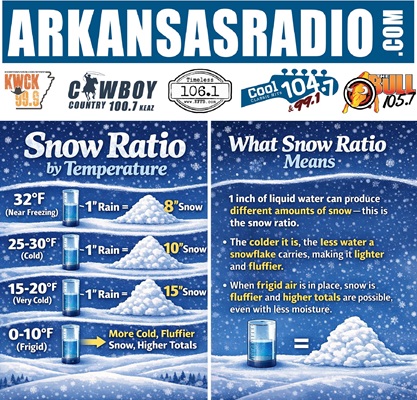
Meteorologists say it’s not just how much moisture is in a storm that determines how much snow will fall — temperature plays a critical role in how snow accumulates. Colder air produces lighter, fluffier snowflakes that stack more efficiently, often resulting in higher snow totals even when moisture is limited. Warmer temperatures create heavier, wetter snow that compacts more quickly and reduces total accumulation.
Forecasters use snow-to-liquid ratios to estimate snowfall amounts based on temperature. When temperatures drop into the teens and twenties, a small amount of moisture can produce significant snowfall. When temperatures hover near freezing, snowfall totals are typically lower despite heavier precipitation.
ArkansasRadio.com has published a simple chart showing how temperatures control snow totals, helping residents better understand what forecast numbers really mean for local impacts, road conditions, and travel planning.
Drivers are urged to monitor changing conditions closely, limit travel during peak snowfall, and prepare emergency kits in case of power disruptions. Residents should also ensure adequate heating, food supplies, and backup lighting are available.
Listeners are encouraged to stay informed with weather updates every twenty minutes on ArkansasRadio.com stations as the storm evolves.
For community announcements, local events, or public information you would like to share with the ArkansasRadio.com radio stations, submit your event at:
👉 https://arkansasradio.com/submit-event/